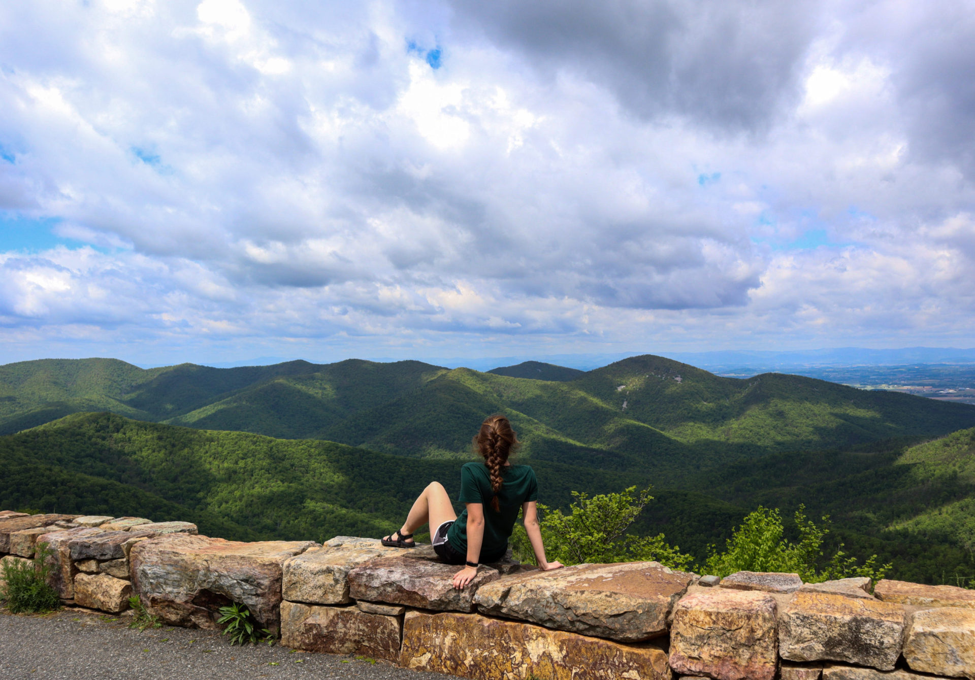
In the midst of endless Shenandoah National Park hikes to explore, these are 6 that any hiking fanatic is guaranteed to love. After researching and hiking these trails myself, I believe that these trails represent the best of the park.
Table of Contents
- Preparing to Conquer These Shenandoah National Park Hikes
- Upper Hawksbill Trail
- Dark Hollow and Rose River Falls Loop
- Old Rag Mountain Loop
- Blackrock Summit Trail
- Bearfence Mountain Trail
- Stony Man via Appalachian Trail
- More From Shenandoah National Park
Preparing to Conquer These Shenandoah National Park Hikes
Entrance Passes and Permits
To enter Shenandoah National Park, you’ll need one of the follow entrance passes:
- Shenandoah Entrance Pass (valid for 7 days, purchase at park entrance station or online here)
- Shenandoah Annual Pass (valid for 1 year, purchase at park entrance station or online here)
- America the Beautiful Pass (valid for 1 year at ALL National Parks, Monuments, and Lakeshores, limited availability at park entrance station or can purchase online here)
Additionally, if you choose to tackle Old Rag Mountain, you will also need a day-use permit. More information on this can be found here.
Accommodations
I highly recommend camping or renting a cabin inside the park. This is helpful because it will cut down on driving distance and maximize your time inside the park. We opted to stay at Big Meadows Campground because it’s centrally located at mile-marker 51.2 within the park. It was also close to a lot of the trails we wanted to do.
If you choose to stay at Big Meadows they have the following options:
- Traditional camping (Both walk-in tent only and RV/tent sites are $30. We stayed in walk-in tent site 21 and loved the proximity to the bathrooms and privacy from other campers)
- Group Camping Sites (Two are available and are $75/night)
- Big Meadows Lodge Rooms (prices are dependent on room selection)
- Big Meadows Lodge Cabins (prices are dependent on room selection)
To reserve a campsite visit this site here and to find out more about Big Meadows Lodge accommodations go here.
There is also a camp store, dining hall, gas station, and visitor center on the Big Meadows campus, which is located across from the iconic Big Meadows. Big Meadows is a popular stargazing spot and very conveniently located if you choose to stay here.
Campgrounds in Shenandoah National Park
- Matthews Arm Campground (mile-marker 22)
- Skyland Resort and Lodging (mile marker 42)
- Big Meadows Lodging and Campground (mile-marker 51)
- Lewis Mountain Cabins and Campground (mile-marker 57.5)
- Loft Mountain Campground (mile-marker 80)
Find information about all accommodations here.
Preparing for Hikes
Gear to Bring
- Trail Maps (download them here)
- Hiking Boots or Trail Runners with great tread
- Merino Wool or Smart Wool Socks
- Water Reservoir
- 1/2 liter for each hour of hiking
- Electrolytes for hydration
- Small day pack
- Trail snacks/meals
- 10 Essentials (view list here)
Most Shenandoah National Park hikes have some decent incline, and if you’re not used to this you will need to take it slow. Training on steps or local incline routes can also make it easier when you visit the park. In addition, be sure you can handle the distance, especially with lengthier hikes like Dark Hollow Falls and Rose River Falls Loop or Old Rag Mountain. Be prepared for any expected weather conditions and stay hydrated on the trails!
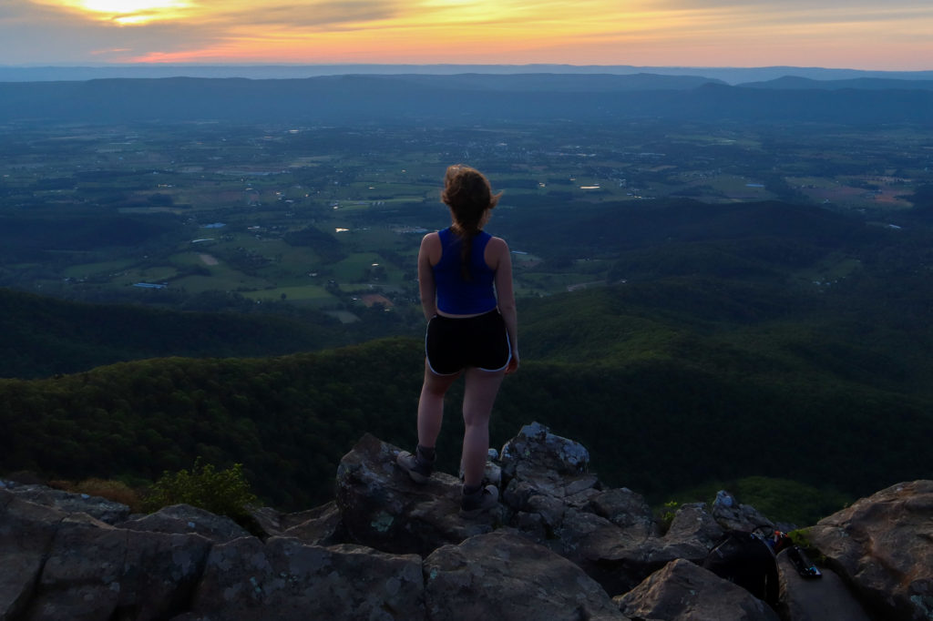
Upper Hawksbill Trail
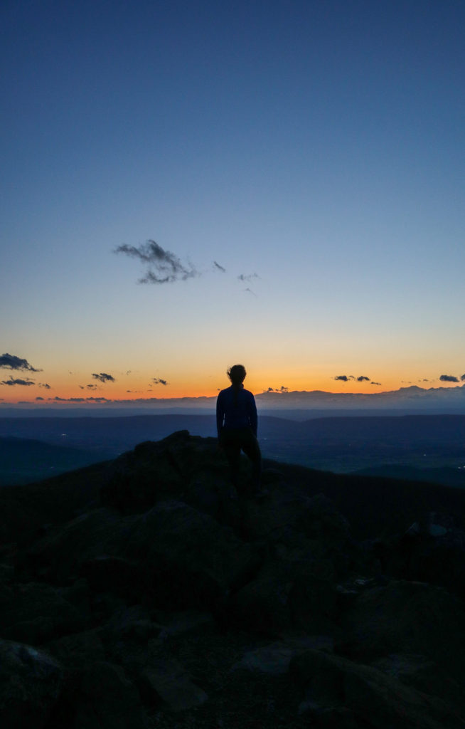
Located at mile marker 46.5 on Skyline Drive, Upper Hawksbill Trail makes the perfect sunset hike. While this hike is an out and back that should only take an hour total, we hit the trail an hour before sunset. This gave us time to watch the sun go down and take in the epic summit views before heading back down to Skyline Drive.
The trail incline is very gradual with very few rocks spattered across the trail. This was the first of our Shenandoah National Park hikes this trip. After driving 12 hours from Michigan and setting up camp, we opted to catch our first sunset of the trip at Hawksbill Summit.
Hawksbill Summit is the highest point in the park at 4,049 feet and is east-facing, so it’s ideal for sunset. Coming from the Upper Hawksbill Trail, you’ll see an Appalachian Trail shelter at the summit. Make sure to go up to the right to see the stone platform that signifies the highest point in Shenandoah National Park.
An alternative trail that takes you to this summit is Hawksbill Summit Trail. This is located at mile marker 45.5 and climbs 672 feet in elevation in just 1.5 miles. We chose not to do this trail because the other trail had a more gradual incline for us to adjust to and the trailhead was closer to our campground.
Whichever trail you take, you’re sure to catch epic views on this amazing hike. It’s a great addition to any day of adventure in Shenandoah National Park.
Trail Stats
- Distance: 2.1 miles
- Elevation Gain: 488 feet
- Trail Format: Out and Back
- Difficulty Rating: Moderate
- Duration: ~1 hour
- Parking: Upper Hawksbill Trailhead at mile-marker 46.5
Find this trail on Alltrails here.
Alternative Trail
Hawksbill Summit Trail
- Distance: 1.5 miles
- Elevation Gain: 672 feet
- Trail Format: Out and Back
- Difficulty Rating: Moderate
- Duration: ~1 hour 10 min
- Parking: Hawksbill Gap Trailhead at mile-marker 45.5 (take Lower Hawksbill Trail)
Find this trail on Alltrails here.
Dark Hollow and Rose River Falls Loop
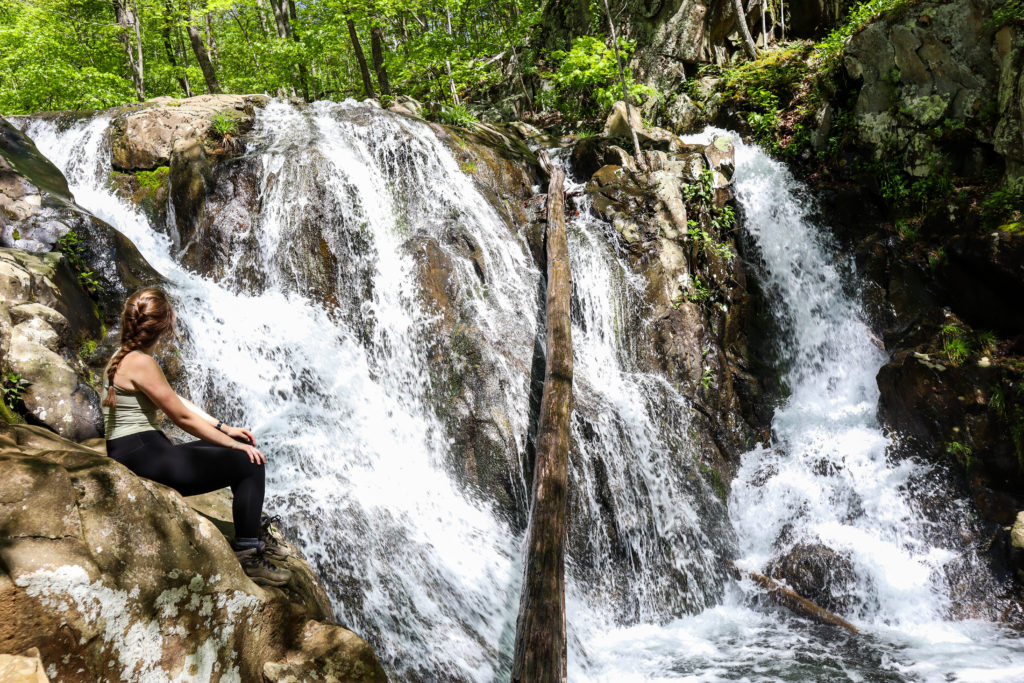
If you’re a waterfall lover like me, you can’t leave Shenandoah National Park without doing this hike.
To do this trail you’ll want to arrive at the Dark Hollow Falls Trailhead early to secure a parking spot. This trailhead is located at mile marker 50.7 on Skyline Drive. Since the parking lot is only big enough for a couple dozen cars and this is one of the most popular waterfall trails in the park, weekdays and early mornings will make for a better experience.
First Waterfall: Dark Hollow Falls
From the trailhead you’ll hike down around 0.7 miles to the base of Dark Hollow Falls. The first part of the trail is gradual and follows the Hogcamp Branch of the Rose River. When the trail begins to go downhill at a steeper incline, you’ll know that the best views are coming up quick.
Dark Hollow Falls is a stunning waterfall that drops around 70 feet in a series of cascades. This might just be my new favorite waterfall.


Second Waterfall: Rose River Falls
After reaching the bottom of Dark Hollow Falls, there’ll be three different trails you can take. We took the middle trail called the Rose River Loop Trail. The two trails on either side are branches of the Rose River Fire Road. Additionally, you could also take the fire road to the left to reach Rose River Falls.
I liked the route we took because it winds along the river. It also offers an easier route back down the fire road before climbing back up to the trailhead.
After about 1.5 miles of rocky terrain and some steep incline, you’ll reach Rose River Falls. Rose River Falls features a 67-foot drop and a swimming hole at the bottom. It wasn’t warm enough for us to dive in during our visit in May, but we saw others go in. This would be a great place to swim on a hot day.
From there you’ll follow the trail until it intersects with Rose River Fire Road. This is also where you could go up to Fishers Gap Overlook, which is an alternative trailhead for this trail. The fire road will take you back to the same intersection point at the base on Dark Hollow Falls, where you’ll go back up the way you came to the Dark Hollow Falls Trailhead.
Trail Stats
- Distance: 6.5 miles (Alltrails claims that it’s 5.1 miles, but my Fitbit showed closer to 7)
- Elevation Gain: 1,443 feet
- Trail Format: Lollipop
- Difficulty Rating: Moderate
- Duration: ~3 hours
- Parking: Either at Dark Hollow Falls Trailhead (mile-marker 50.7) or Fishers Gap Overlook to do this loop backwards (mile-marker 49.4)
Find this trail on Alltrails here.

Alternative Trails
Dark Hollow Falls Trail
- Distance: 1.4 miles
- Elevation Gain: 564 feet
- Trail Format: Out and Back
- Difficulty Rating: Moderate
- Duration: ~1 hour
- Parking: Dark Hollow Falls Trailhead at mile-marker 50.7
Find this trail on Alltrails here.
Rose River Falls Trail
- Distance: 2.4 miles
- Elevation Gain: 656 feet
- Trail Format: Out and Back
- Difficulty Rating: Moderate
- Duration: ~ 1 hour 23 minutes
- Parking: Fishers Gap Overlook at mile-marker 49.4
Find this trail on Alltrails here.
Old Rag Mountain
Old Rag Mountain is the pinnacle of Shenandoah National Park hikes. It only stands at 3,284 feet, meaning that it’s not the highest point in Virginia or even in Shenandoah National Park.
Nonetheless, the extreme inclines and epic rock scramble claim this mountain’s spot as the most dangerous hike in Virginia.
While it’s the most dangerous, it’s also one of the most rewarding trails and is worth the difficult trek.
I had too much to say about climbing this mountain, so I wrote a whole blog post on it that you can read here:

Hiking Old Rag Mountain: A Complete Guide to this Bucket List Hike
Hiking Old Rag Mountain in Shenandoah is an unforgettable experience. Here’s everything you need to know to tackle this bucket list hike.
Blackrock Summit Trail
This short and easy summit hike is the perfect addition to any Shenandoah National Park adventure. Blackrock Summit sits at an elevation of 3,120 feet and features a stunning boulder field at the summit.
Blackrock Summit Trailhead is located just north of mile-marker 85 on Skyline Drive. The trail we did here was Blackrock Summit via Trayfoot Mountain and Appalachian Trail. We did this hike the day after summiting Old Rag and thought it was a perfect easy hike for our recovery day.
After the short ascent to the top, you’ll find amazing views and a boulder field. For an optional challenge, you can scramble to the top of the rocks for a better vantage point. Of course we had to do this to secure the best views. Most of the rocks are pretty stable, but be extremely careful if you decide to climb here.
We also saw many spiders on the rocks and there may be snakes in the summer months as well. They shouldn’t bother you, but be sure to watch where you put your hands.
Whether you scramble to the top or enjoy the views from the trail, this is one of many Shenandoah National Park hikes you just can’t miss!


Trail Stats
- Distance: 1.1 miles
- Elevation Gain: 180 feet
- Trail Format: Loop (or Out and Back)
- Difficulty Rating: Easy
- Duration: ~30 minutes
- Parking: Blackrock Summit Trailhead just north of mile-marker 85
Find this trail on Alltrails here.
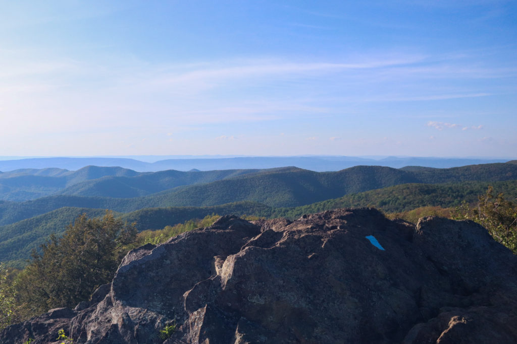
Bearfence Mountain Trail
This hike is short but sweet. Clocking in at only one mile, this hike features an optional rock scramble that is so fun to do. Bearfence Mountain stands at 3,560 feet.
The trail starts at Bearfence Mountain Trailhead at mile-marker 56.4. After parking at the trailhead and crossing Skyline Drive, the incline begins immediately.
Loop Trail: Including the Rock Scramble
If you’re interested in doing the rock scramble on this trail, you’ll want to go straight/left at the fork in the trail.
For anyone that’s not familiar, rock scrambling is an added challenge to any hiking trail. It’s not like rock climbing or bouldering, but it does offer the opportunity to use both your hands and feet to navigate over, under, and around rocks that stand in your way. For guidance on how to tackle your first rock scramble, check out my tips here.
In my opinion, the best views on Bearfence Mountain are at the top of the rock scramble. It offers 360 degree views and would be the perfect vantage point for either sunrise or sunset. You will want a headlamp and confidence hiking in the dark to attempt either.
All of the scrambling routes are marked with blue blazes and the route is the perfect challenge for any hikers who are looking to get into rock scramble hikes or just think that scrambling is fun.
Continue along the trail until the summit at the top. The summit is marked with a sign and we even saw and someone doing the AT setting up camp nearby. From there you’ll continue around the loop and back down the way you came at the fork.
Out and Back Trail: Bypassing the Rock Scramble
If you’re afraid of heights or rock scrambling just isn’t your thing, you can bypass the rock scramble at the first fork in the trail. Here you’ll want to go right. This will take you up to the summit and afterwards you’ll go back down the way you came. There are still great views going this route, but I’ll admit I think the rock scramble is much more worth it.
Also it is important to note: the people that recommend Bearfence Mountain as a sunrise hike do not go this route! The official summit does not face the right direction.
Whichever route you choose, this is a fun, easy hike to add to your Shenandoah bucket list!
Trail Stats
- Distance: 1 mile
- Elevation Gain: 242 feet
- Trail Format: Lollipop/Loop (or Out and Back)
- Difficulty Rating: Moderate
- Duration: ~32 minutes
- Parking: Bearfence Mountain Trailhead at mile-marker 56.4
Find this trail on Alltrails here.
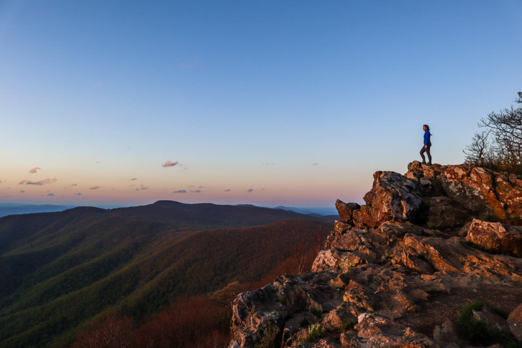
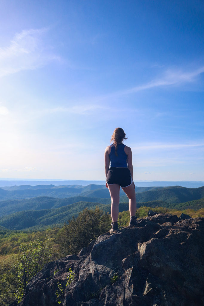
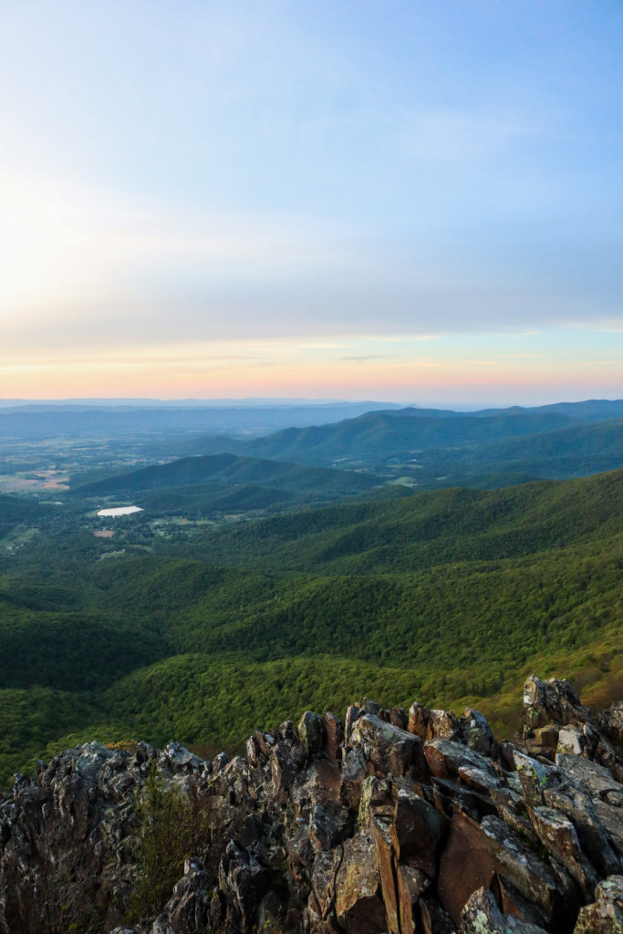
Stony Man via Appalachian Trail
If you’re looking for the perfect sunset hike for your last day in Shenandoah National Park, this is it. That’s when we opted to do this trail. In addition, I’ve also heard that it’s great at sunrise, but I can’t speak to this myself.
After some confusion finding this trailhead, we turned into the Skyland Upper Loop entrance to the resort and found the trailhead parking immediately to the right. This is located between mile-markers 41 and 42.
Because we were running a little late, we powered through this hike. However, we were pleasantly surprised to find the incline pretty easy after hiking Old Rag Mountain the day before.
Navigating to Stony Man Summit
Pay close attention to blazes on this trail. Blue blazes signify Shenandoah National Park, white blazes represent the Appalachian Trail, and the yellow blazes are for the horse trail on the mountain. The first section of the trail will be marked with white blazes. After going straight through the first intersection, you’ll go right at the second fork.
The views at the summit were beyond worth the 0.75 mile trek to get there. Stony Man is the second highest mountain in Shenandoah National Park at 4,002 feet. While the sunset wasn’t the best I’ve seen, the glow over the valley, incredible rock formations, and stunning views of Skyline Drive were a great way to end the trip.
Headlamps are a definite must to hike back down the other side of the loop back down to the parking area. After going back down the other side of the loop, you’ll go straight through the next two forks in the trail, following the white blazes back down to the parking area.
Stony Man is one of several classic Shenandoah National Park hikes that can be enjoyed any time of day, but I highly recommend making this a sunset hike during your visit.
Trail Stats
- Distance: 1.5 miles
- Elevation Gain: 318 feet
- Trail Format: Lollipop
- Difficulty Rating: Easy
- Duration: ~46 minutes
- Parking: Stony Man Trailhead between mile-markers 41 and 42 off of Skyland Upper Loop
Find this trail on Alltrails here.
Liked this post? Pin it for later!

More From Shenandoah National Park

The 5 Best Overlooks on Skyline Drive
Planning a trip to Shenandoah National Park? These are the 5 best overlooks on Skyline Drive from my visit that I recommend you check out.
Hiking Old Rag Mountain: A Complete Guide to This Bucket List Hike
Hiking Old Rag Mountain in Shenandoah is an unforgettable experience. Here’s everything you need to know to tackle this bucket list hike.