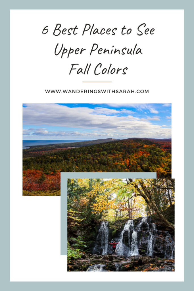
Searching for your new favorite spot to see Upper Peninsula fall colors? Look no further than these 6 best places for chasing fall foliage.
And for help planning your next fall trip, check out my Epic 4-Day Upper Peninsula Fall Trip Itinerary.
Table of Contents
- When to Chase Upper Peninsula Fall Colors
- Leave No Trace Principles
- Covered Drive
- Hungarian Falls
- Mount Baldy
- Brockway Mountain
- Sugarloaf Mountain
- Tahquamenon Falls State Park
- Epic 4-Day Upper Peninsula Fall Trip Itinerary
When to Chase Upper Peninsula Fall Colors
The hardest part about planning a fall color trip is getting the timing right.
You will want to aim for peak fall color, which just refers to that period of time when the most leaves have turned—when there are few green trees left but yet very few trees have lost their leaves.
The Upper Peninsula of Michigan hits peak fall color before the Lower Peninsula. Typically, this happens sometime between the last week of September and the first two weeks of October. In 2022, we visited from October 6-10 and felt that we were only a day or two after peak fall color, mostly due to a snowstorm that brought down leaves.
To plan your trip, use fall foliage predictors like this one here from the Smoky Mountains that does some of the best fall color forecasts for the entire country. Also check local tourism websites to get a different perspective on fall color predictions. For these recommendations, you’ll want to look at Pure Michigan, Up Travel, and Visit Keweenaw. Closer to your trip, you can also check social media and other websites like Alltrails to get a real-time look at the status of fall colors in that area.
It’s also important to know that the Keweenaw Peninsula has its own microclimate which can result in earlier fall colors than the rest of the Upper Peninsula. In addition, foliage along any of the lakeshores in Michigan tends to be at least a week behind more central areas.
Leave No Trace Principles
The state park signs in the Upper Peninsula say it best: take only pictures and leave only footsteps.
It’s so important to preserve the environment for those that will visit in the years and generations after us. You can do this by picking up after yourself and others to leave every place better than you found it. Also be respectful to others on the trail and follow any trail rules.
The Upper Peninsula of Michigan is one of the wildest parts of the state and that’s part of its beauty. Let’s all do our part to keep it wild.
To learn more about leave no trace principles and how you can do your part, check out the link here.
Covered Drive
Covered Drive, also referred to as Covered Road, is arguably one of the best fall scenic drives in the Upper Peninsula.
If you like scenic fall drives at all, this one will blow you away.
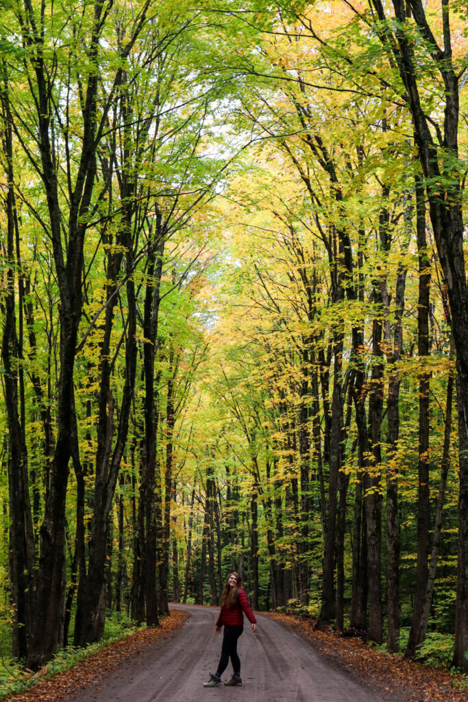
It’s a dirt two-track that spans less than 10 miles and winds through a stunning forest. The trees along the road stand tall and drape over the roadway. This creates a tunnel effect that you can’t find in many places.
In October of 2022, we found vibrant yellows and oranges here, making for a magical drive along this route.
There are many pull-offs, so be sure to get some great pictures with the fall colors here. We visited on a Friday around noon and found that most of the traffic was coming from the Houghton direction and we only saw around 10 cars while we were there. With our itinerary, we ended up coming from Chassell and ending at Houghton Canal Road.
It’s important to note that there are two Covered Drives in the Keweenaw Peninsula. The official one is on US-41 and is an 18-mile stretch just south of Copper Harbor. The route I’m talking about is typically referred to as Covered Road. However, when searching on Google Maps, this road is actually Covered Dr. and Covered Road will not return any results. On Apple Maps, the road is listed as S Superior Road.
To find the beginning of the scenic drive with Google Maps use this link here and for Apple Maps use this link here.
Get ready for some incredible fall color on this scenic drive!
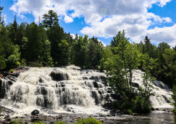
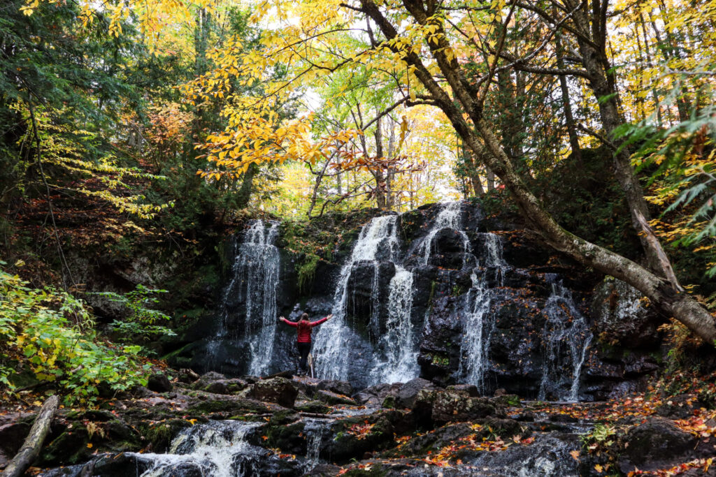
Hungarian Falls
Hike this trail to see not one, not two, but three amazing waterfalls.
While you can certainly hike this trail any season for some incredible views, the surrounding foliage really brings the area to life in the fall.
Located near Hubbell, Michigan, Hungarian Falls drops almost 100 feet along Dover Creek as it flows into Torch Lake.
How to Hike Hungarian Falls Trail
To hike this trail, park along Golf Course Road and head straight in on the path. Up ahead you’ll find three branches in the trail. If you look closely, you can see water flowing at the end of the center trail. I’d recommend taking this branch; however the right branch will also work. The trail leads to a dam that you will continue past. A wooden sign should be to your right and there’ll be a holding pond on your left.
Up ahead will be Upper Hungarian Falls. There are two viewpoints: one from the bottom that involves a steep descent and one further along the trail that looks down from the top of the falls. This waterfall drops 20-feet, cascading across the wide section of rock.
Head back the way you came, straight past the dam. This will lead you first to a smaller drop in the creek, where a log is there for you to walk across for a fun side adventure. After returning to the trail, you’ll come to the Middle Falls next. Look down from the top before going just down the trail, where you’ll find another steep descent to the bottom. It’s well worth it to see this stunning 20-foot waterfall.
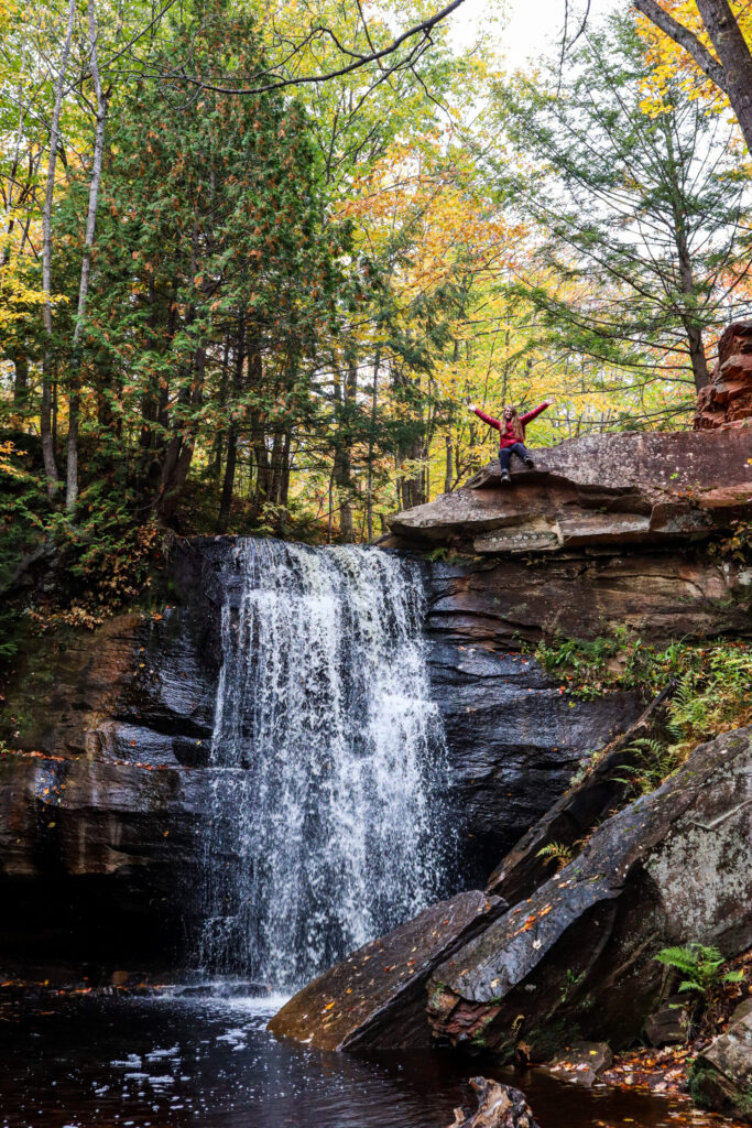
Down the trail even further is the Lower Falls. This is the biggest of the three falls, however there is no trail access to the bottom. You can look down at the 50-foot drop and then out towards Torch Lake in the distance.
To get back to your car, I’d recommend going back the way you came to avoid getting lost. However, if you have a great sense of direction, there are a few shortcuts.
Hungarian Falls Trail
- 1.7 miles
- 269 feet in elevation gain
- Out and Back
- Rated Moderate
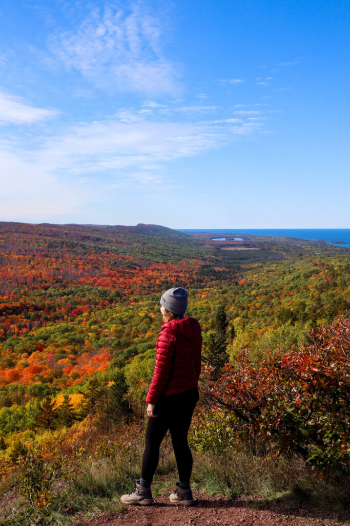
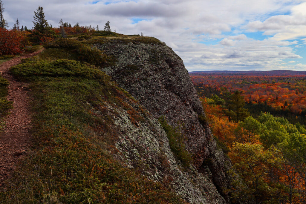
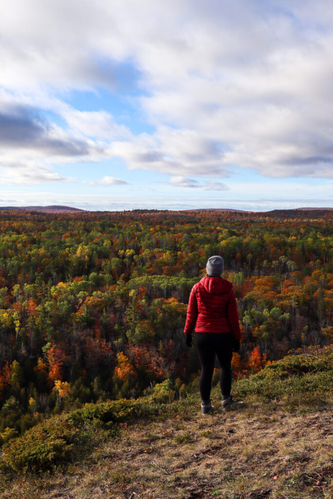
Mount Baldy
Located near Mohawk, Michigan, this is probably my favorite trail I’ve hiked in the Keweenaw Peninsula. After hiking it previously in the summer, it immediately came to mind when I was planning my fall color trip.
And the fall colors at the summit of this hike do not disappoint. At 1,320 feet above sea level and 730 feet above Lake Superior, this mountain offers great views of the surrounding fall foliage.
Often referred to as Lookout Mountain, Mt. Baldy, or the Nicole Bloom Memorial Trail, this trail is a lesser-known gem in the area. Let’s all do our best to keep this amazing place special for generations to come.
How to Hike Nicole Bloom Memorial Trail
With only two intersections to cause confusion on this trail, it’s a straight shot up the mountain. After parking at the trailhead, you’ll take the first fork to the right and then after about a mile to the next fork, you’ll head to the left. You’ll know you’re on track when you get to the creek crossing. And before the final stretch there is a gate, signaling that no motorized vehicles are permitted past that point.
This entire hike took us 5 hours; however we really took our time along the way and spent an hour exploring, taking pictures, and eating snacks at the summit. Going up will take you twice as long as the hike down and there is a false summit about a half mile away from the top. I recommend going on a calmer day because the wind can get cold at the summit.
Please respect the rules of this trail while you are here! In addition to the standard leave no trace principles to follow, there are also no dogs permitted. It’s unfortunate, I know, but if you have a dog that needs to come hiking with you, then this isn’t the trail for you. I would recommend a trail nearby like Bare Bluff Trail instead, where dogs are allowed.
See you on the trail!
Nicole Bloom Memorial Trail
- 6.5 miles (may be closer to 7 miles)
- 826 feet in elevation gain
- Out and Back
- Rated Moderate
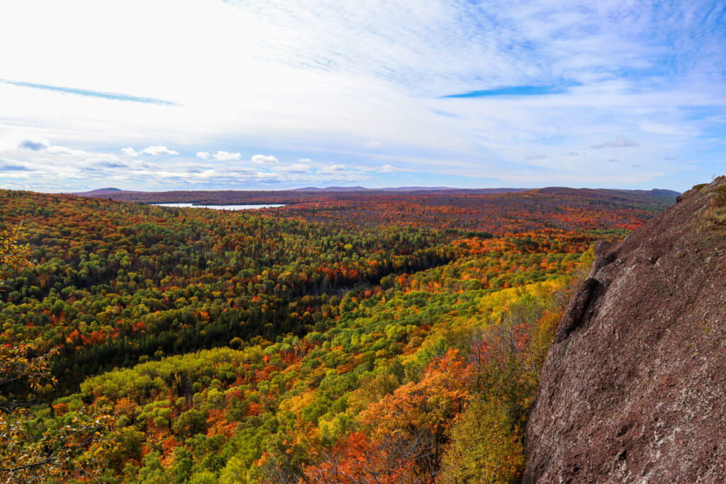
Brockway Mountain
Ask anyone in the Keweenaw Peninsula—Brockway Mountain Drive is the best scenic drive in the area for fall colors. Or for views any time of year.
Brockway Mountain stands at 1,320 feet in elevation and 720 feet over Lake Superior. The drive is 9.5 miles and goes from just past Eagle Harbor to Copper Harbor.
Along the drive you’ll find several scenic turnouts and even some hiking and mountain biking trails. But the best views are from the summit. There’s a parking lot, pit toilets, and some informational signs over the West Bluff. For the best chance of avoiding crowds on Brockway Mountain, try visiting on a weekday if possible.
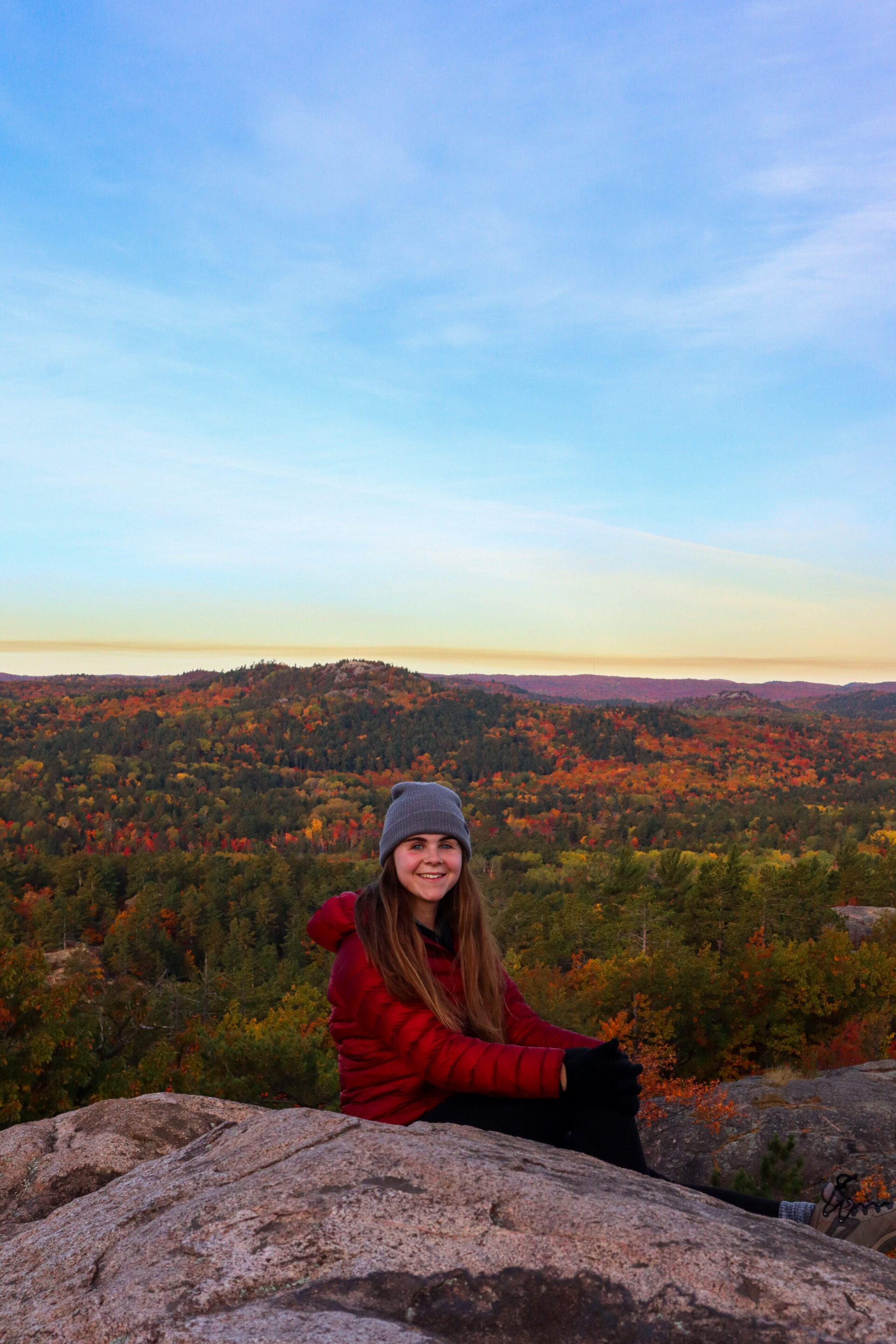
We went up to the summit twice in one day, once for lunch and to see the fall colors and again later to eat dinner and watch the sunset. Look towards Lake Superior for the best sunset views, although we saw it directly over the distant Mount Baldy in October. It does get chilly up on Brockway Mountain after sunset, so bring layers.
I definitely think it’s worth it to go awhile before sunset and stay or once earlier in the day and then again later like we did. That way you get the full experience and all the epic views this mountain has to offer. Hangout in the cute town of Copper Harbor in the meantime or explore some other trails in the area.
You absolutely can’t miss this mountain for Upper Peninsula fall colors!
Sugarloaf Mountain
Located in Marquette, Sugarloaf Mountain is 1,000 feet in elevation and stands 470 feet above Lake Superior. The summit offers 360-degree views of the surrounding area, which makes it the perfect hike to chase Upper Peninsula fall colors.
Expect to see all of Marquette, the Lake Superior coastline, nearby Hogsback Mountain, and even Black Rocks from one of several observation decks at the top of Sugarloaf Mountain.
There are a couple ways to hike this trail. The recommended route is a loop trail, but I typically hike it as an out and back. Two parking lots are available, but the second of the two is my go-to.
Start the trail and go left around the loop. This will take you up the more difficult part of the trail until the two sections meet at the stairs. While it’s a little harder to go this way, it’s also faster. To make the hike easier, head right and take that part of the loop instead. The stairs are non-negotiable, and several flights will take you up to the summit.
On your way down, either go back whichever way you came, or take the other section of trail to do the complete loop. A sign at the base of the stairs will point you in the right direction.
We hiked this trail just after sunrise and the golden glow on the fall colors in the area was absolutely breathtaking.
If you’re in the Central Upper Peninsula during the fall, this hike is one you can’t miss.
Sugarloaf Mountain Trail
- 1.4 miles
- 295 feet in elevation gain
- Loop trail
- Rated Moderate
Tahquamenon Falls State Park
Tahquamenon Falls State Park is home to the largest waterfall in Michigan, so it’s only fitting that it also makes the list of best places for Upper Peninsula fall colors!
Located in Paradise, Michigan, Tahquamenon Falls State Park is a little remote even compared to the rest of the Upper Peninsula, but well worth the drive out there.
Tahquamenon Falls State Park should make your bucket list for any season, but you can’t go wrong with visiting during the fall to enjoy the fall colors as well!
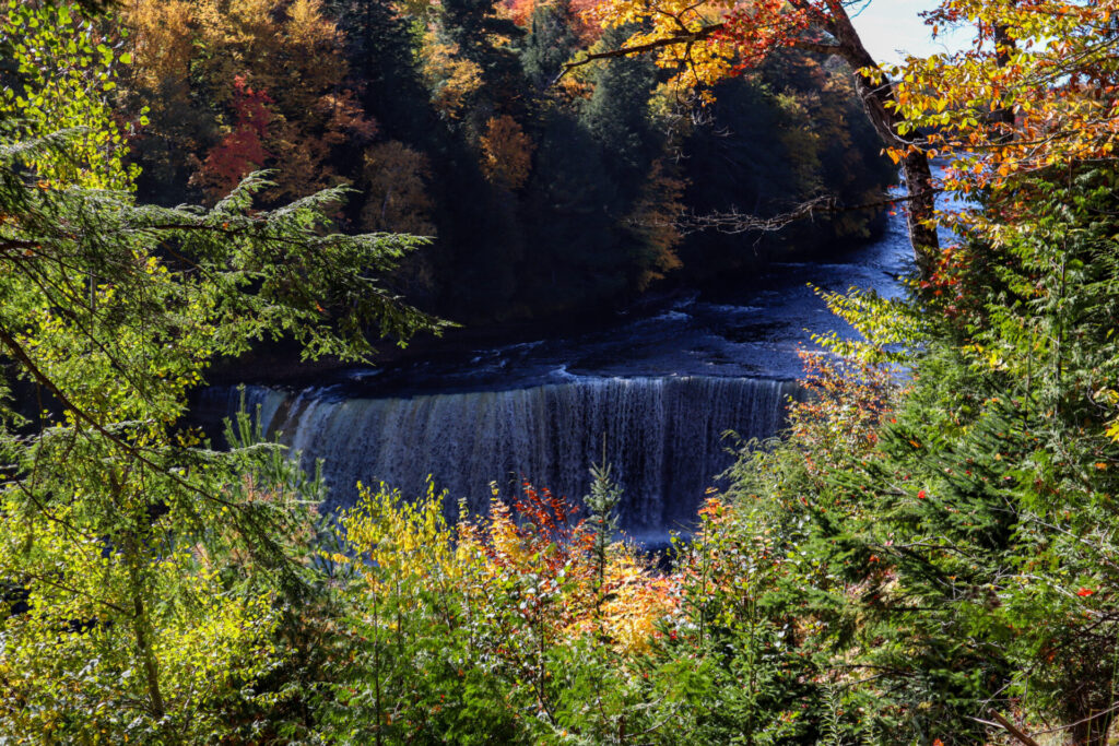
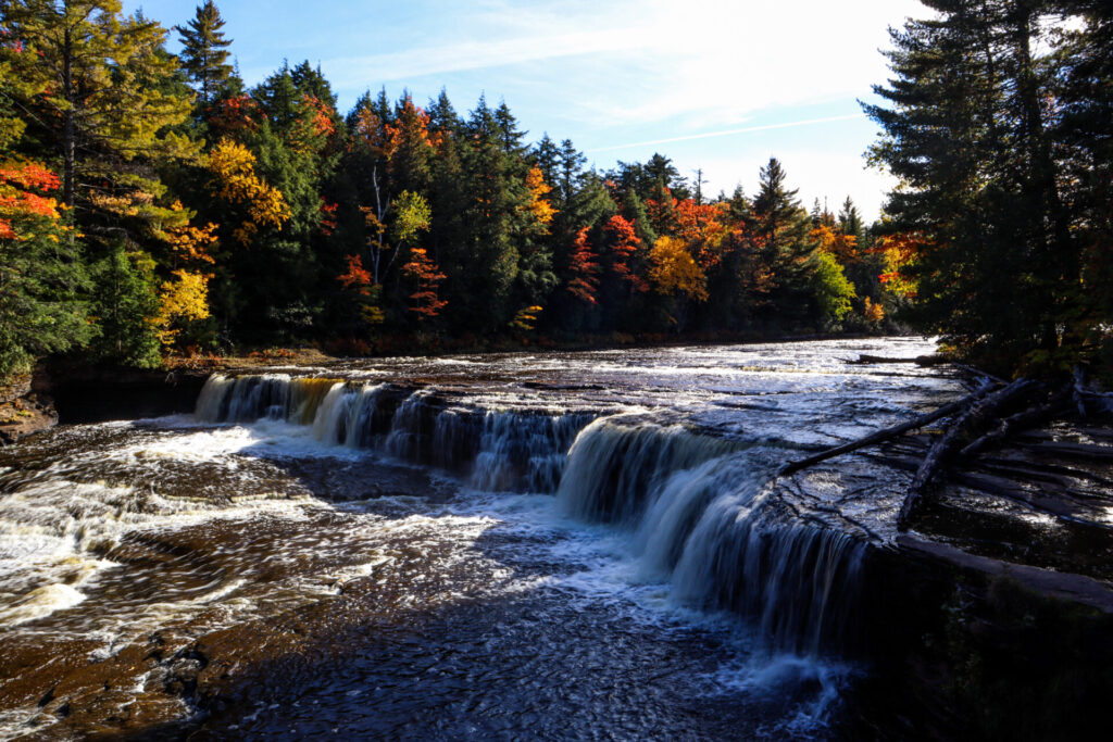
Upper Tahquamenon Falls
Upper Tahquamenon Falls is the single biggest waterfall in Michigan. It is 200-feet across and falls 50-feet into the Tahquamenon River. At its peak flow during the spring season, this waterfall dumps over 50,000 gallons of water per second.
This waterfall has also been nicknamed “Root Beer Falls” due to the tannins in nearby cedar swamps that have turned the water a reddish-brown color.
There are several options for hiking to Upper Tahquamenon Falls, including a 10-mile hike that goes to Lower Tahquamenon Falls as well. My go-to trail is a variation on the Tahquamenon Upper Falls Loop described on Alltrails.
Head straight in from the parking lot until you hit the trail along the river. From there you can go to the left a short distance to access the first overlook of the falls. Continue the other way on the trail and make sure you stop at all of the overlooks before you get to the stairs for the main viewing platform. Trust me, it won’t be the same after standing right next to the falls. And the framing of the fall colors around the view of Upper Tahquamenon Falls is pretty spectacular. Over 100 steps will take you down to the main viewing platform that lets you get up close to the falls. After you’ve taken in the views, head back out the way you came.
Tahquamenon Upper Falls Loop
- 1.5 miles (may be inaccurate if you take out and back route described above)
- 183 feet in elevation gain
- Loop (or out and back)
- Rated Easy
Lower Tahquamenon Falls
Lower Tahquamenon Falls has its own entrance in Tahquamenon Falls State Park and is located 4 miles downstream of Upper Tahquamenon Falls.
It’s composed of 5 smaller cascades only dropping around 20-feet around an island.
Previously, the only way to access the island was by rowboat. However, in 2022 a new walking bridge was installed upstream of the falls to make the island more accessible.
The Lower Tahquamenon Falls Trail described on Alltrails includes a loop that goes to the nearby campground. This addition is optional and takes you away from the falls. If you’re more interested in exploring along the Tahquamenon River and on the island, I recommend staying on the boardwalk all the way to the island and heading back the way you came.
Lower Tahquamenon Falls offers a completely different experience than the Upper Falls and it’s well worth exploring while you’re there.
Lower Tahquamenon Falls Trail
- 3.2 miles (shorter without added loop)
- 200 feet in elevation gain
- Loop (or out and back)
- Rated Moderate
Epic 4-Day Upper Peninsula Fall Trip Itinerary
I put hours into planning a trip to see the Upper Peninsula fall colors that included all the places mentioned above and many more.
To help you also take this incredible trip, I designed an extensive guide that connects to both Google and Apple Maps and has all my trip research available to you.
You can expect 28 locations, including hikes, driving routes, scenic stops, dining options, and what accommodations we used. All stops come with links, detailed information, and voice memos with more about my personal experience. I’ve also provided my pictures of what all these places looked like during my fall visit.
I’ve been traveling to the Upper Peninsula for years and these experiences helped me to plan my very first fall trip there.
You can find the itinerary on Thatch, a great app that anyone can download to have entire travel guides right at your fingertips. It’s available for a small cost, which helps to support me as I chase new adventures and share them with you.
You can find the complete guide here.
Liked this post? Pin it for later!